


Feature Statistics
Purpose
The tool is provided for calculating basic statistics for point, multipoint, polyline and polygon features.
Description
Feature Statistics tool allows to easily gather selectable set of basic feature statistics for a given feature class of any geometry type with various output options.
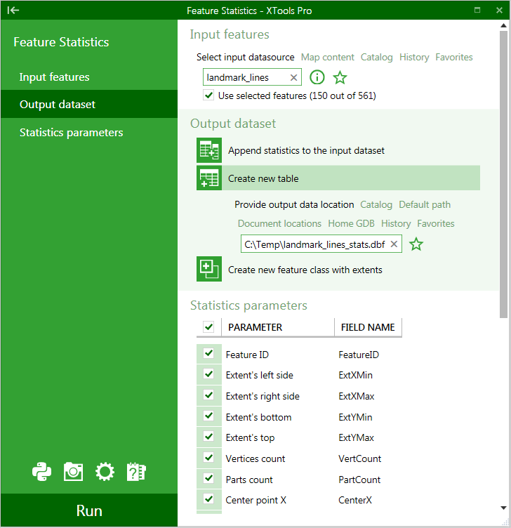
Calculating feature statistics
- Select the "Feature Statistics" tool from the XTools Pro Table Operations menu.
-
Select input features for gathering basic statistics.
-
Select required output option and specify the name and location of the output table or feature class.
-
Select statistics parameters to calculate and modify default field names if required.
-
Press Run.
There are following output options available:
-
Add statistics to input dataset
- attribute fields with calculated statistics will be added to the input dataset
-
Create new table
- a new table with fields containing calculated statistics will be created
-
Create new feature class with extents
- a new feature class with input feature extents will be created, fields with calculated statistics will be added to the attribute table
Statistics parameters and applicable geometry types are given in the table below:
|
Statistics parameter |
Comment |
Applicable geometry |
|
Feature ID |
Input feature ID |
Points/Polylines/Polygons |
|
Extent's left side |
Feature extent minimum X coordinate |
Polylines/Polygons |
|
Extent's right side |
Feature extent maximum X coordinate |
Polylines/Polygons |
|
Extent's bottom |
Feature extent minimum Y coordinate |
Polylines/Polygons |
|
Extent's top |
Feature extent maximum Y coordinate |
Polylines/Polygons |
|
Vertices count |
Number of vertices in a feature |
Polylines/Polygons |
|
Parts count |
Number of parts in a feature |
Polylines/Polygons |
|
Interior rings count |
Number of interior rings in a polygon |
Polygons |
|
Exterior rings count |
Number of exterior rings in a polygon |
Polygons |
|
Center point X |
Feature center X coordinate |
Points/Polylines/Polygons |
|
Center point Y |
Feature center Y coordinate |
Points/Polylines/Polygons |
|
Nearest to center point X |
X coordinate of a real point nearest to center |
Multipoints |
|
Nearest to center point Y |
Y coordinate of a real point nearest to center |
Multipoints |
|
From-point X |
X coordinate of a polyline "From" point |
Polylines |
|
From-point Y |
Y coordinate of a polyline "From" point |
Polylines |
|
To-point X |
X coordinate of a polyline "To" point |
Polylines |
|
To-point Y |
Y coordinate of a polyline "To" point |
Polylines |
|
Label-point X |
X coordinate of a polygon label point |
Polygons |
|
Label-point Y |
Y coordinate of a polygon label point |
Polygons |
|
Area |
Polygon area value |
Polygons |
|
Length |
Polyline length or polygon perimeter value |
Polylines/Polygons |
|
Z |
Z coordinate of a point |
Points |
|
Minimal Z |
Minimum Z coordinate of a feature |
Polylines/Polygons |
|
Maximal Z |
Maximum Z coordinate of a feature |
Polylines/Polygons |
|
Average Z |
Average Z coordinate of a feature |
Polylines/Polygons |
|
M |
M value of a point |
Points |
|
Minimal M |
Minimum M value of a feature |
Polylines/Polygons |
|
Maximal M |
Maximum M value of a feature |
Polylines/Polygons |
|
Average M |
Average M value of a feature |
Polylines/Polygons |
|
Azimuth |
Azimuth value of a polyline |
Polylines |
|
Rhumb |
Rhumb of a polyline |
Polylines |
|
Directional angle |
Directional angle of a polyline |
Polylines |
---