


Layer Properties Dockable Window
Purpose
Layer Properties grid arranged as a dockable window in ArcMap is provided for seamless work with the basic layer properties. Dockable window allows you to have layer properties always at hand - you can always see them and promptly change as needed without opening the standard modal Layer properties dialog each time you need to check anything (e.g. coordinate system details) or modify any minor thing like transparency for the layer.
Description
Layer Properties is a standard grid with the basic layer properties gathered in one place. This is a new way for working with layer properties in ArcMap avoiding modal dialog boxes that block your map and prevent you from doing anything else. At that, not all layer properties fit the grid capabilities and not all of them you need to view/change often, so we gathered only the basic and often used properties. If you still don't need some of them you can always switch them off or even filter out on the fly. Besides, the Layer Properties component can be disabled as a whole in the XTools Pro Customize dialog.
Note:
Currently Layer Properties dockable window is available for single or multiple selected feature layers, rasters and group layers.
Usage
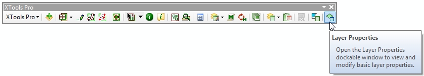
The Layer Properties dockable window can be shown/hidden from the XTools Pro toolbar - select a feature layer in the Table of contents and press the button:
As any dockable window in ArcMap the Layer Properties window can be placed and docked anywhere in ArcMap.
In the open Layer Properties window you can see basic layer properties and modify some of them. Properties shown in gray are read only, basically these are the same capabilities you have with the standard Layer properties dialog:
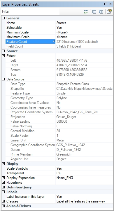
The small toolbar on top of the window allows to:
- Filter layer properties by the entered string
- Refresh layer properties
- Expand or collapse all properties
- Get to the XTools Pro Customize dialog to switch on/off groups of layer properties, if you don't wish to see some of them in this window
Supported data types
Currently ArcGIS feature layers (including Esri CAD feature layers and networks), rasters and group layers are supported.
For the data types these are:
- Simple features (polygons, polylines, multipoints and points)
- Simple and complex junctions and edges in geometric networks
- Rasters
As for data formats, supported are:
- Shapefiles
- Geodatabases (SDE, file and personal)
- CAD files (DWG, DGN, DXF)
- Compressed SDC files
- ArcGIS supported raster formats
Supported layer properties
-
General
- Name
- Selectable
- Min/Max scales
- Feature count
- Field count
-
Source
- Extent
- Data source
-
Display
- Scale symbols
- Transparency
- Display expression
- Hyperlinks
-
Definition Query
- Expression
-
Labels
-
Joins & Relates
- Joins
- Relates
Some of the properties can be changed while the others can be only viewed.
Note:
The features count property requires refreshing, which is why you may see the "???" value for the number of features. In this case simply double click on the smaller icon in the property field. This is managed this way so that you always see the actual number of features in the layer (some features may be deleted and some new features added since the last view). Otherwise it would be required to refresh feature count automatically and for larger datasets this could significantly reduce the overall ArcMap performance.
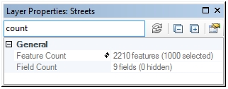
Filtering properties
Layer properties can be not only collapsed but also filtered so that you see only the properties you need.
For example, you can filter by the "count" string, make the window small enough to save place and put it conveniently in ArcMap. This way you can promptly check for the number of features and fields in map layers:
Note:
- Only separate layer properties can be filtered (groups of properties cannot be filtered, but can be disabled, see below).
- Filters are kept between different layers within one ArcMap session.
Disabling/enabling as a whole or by properties
You don't need to see some of the provided layer properties you can disable them in the XTools Pro Customize dialog. Same way the whole Layer Properties component can be disabled for your XTools Pro installation.
---