


Make Polygons from Polylines
Purpose
This tool allows converting polylines into one or multiple polygons. Resulting polygons can be saved in a new shapefile or as a geodatabase feature class.
Description
If no polylines are currently selected, all polylines in the layer will be processed. The polylines do not need to be snapped together. Gaps between polylines will be bridged with a straight line. Source polylines can be single part, multi-part or mixed in the layer.
If polylines from more than one layer will be used to build the polygon, the user will need to assemble the necessary polylines in a separate layer before running this command.
XTools Pro checks the input layer for intersections and places the red marks at the crossing points if the polylines are intersecting without a break. XTools Pro will not break the polylines at the crossing points, the user needs to manually do this as preparatory work and then re-run the command on the new polyline layer. The red marks are graphic objects and may be easily selected and removed if not needed.
Usage
-
Select the "Make Polygons From Polylines" tool from the XTools Pro Feature Conversions menu.
-
Select the input layer containing polylines that you wish to convert to polygons.
-
Specify the name and location of the output feature class.
-
Select the Group by field to group input polylines and create multiple output polygons.
-
Specify the Order by field to connect input polylines in the required order.
-
Specify tolerance if required. This is the minimum distance that may be separating input feature vertices coordinates.
-
Optionally select a point layer with an attributes that will be taken as polygon labels.
-
Press Run to convert polylines to polygons.
Grouping input polylines by a field allows to create multiple polygons specifying a grouping field by which input features will be grouped.
Ordering input polylines by a field allows to specify order in which polylines will be connected while creating polygons. This option can be used if input features ordering is known and is required to be taken into account. By default it is not used. As an example, ordering can be defined by the FID field (digitizing order).
Example:
Input polylines are ordered (FIDs order is considered in the example) as labeled below:
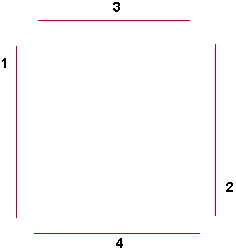
Polygon made without using input features order:
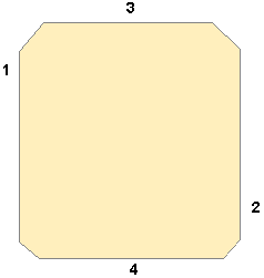
Polygon created using input features order:
---