


New user interface in XTools Pro
The XTools Pro 12 version represented the new look and feel of XTools Pro. Most of the tools have been redesigned with the new unified user interface.
The new tools are now implemented as Geoprocessing tools, they combine usability of advanced modern UI and geoprocessing advantages such as 64-bit and background geoprocessing, use with Python scripts and models etc.
Some of the new interface elements and new capabilities introduced with the new user interfaces are listed below.
Input features control
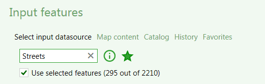
Input features now can be selected from:
-
Map content
- allows selecting dataset from the current map, the option is available if there is at least one layer added to the current map. If selected layer has any selected features there is an option to use only selected features.
-
Catalog
- allows selecting input dataset from disk.
-
History
- allows selecting input dataset from previously used datasets, the option is available if there is any dataset saved in the history.
-
Favorites
- allows selecting input dataset from the Favorites list, the option is available, if there is at least one Favorite dataset.
Output feature class control
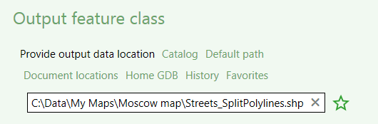
Output feature classes can be specified using:
-
Catalog
- allows specifying output dataset name and location on disk.
-
Default path
- allows reverting back to the default output path.
-
Document locations
- allows selecting output dataset location from the current map document and datasets locations.
-
Home GDB
- allows to output dataset to the Home geodatabase.
-
History
- allows selecting output dataset location from the previously used folders.
-
Favorites
- allows selecting output dataset from the Favorites list, the option is available if there is at least one dataset in the Favorites.
Fields control
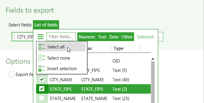
The new fields control allows for more effective fields selection. For that, there are advanced filtering capabilities to filter fields by names and types and information about fields properties provided. Fields can be sorted in the ascending, descending or default order by any of the properties. Besides, as before, there are options to select all fields an once, deselect all fields and invert current selection.
Extent control
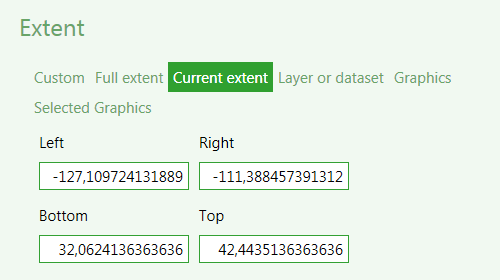
The new extent control now provides more options when specifying extent for the new datasets:
-
Custom extent
- allows to specify extent manually.
-
Full extent
- takes full extent of the map.
-
Current extent
- takes current extent of the map.
-
Layer or Dataset
- allows using extent from the selected layer or dataset.
-
Graphics
- takes extent of graphics on the map.
-
Selected Graphics
- takes extent of selected graphics on the map.
History
The new redesigned tools allow creating and working with the History list. Using history you can faster and easier select both input and output datasets. Besides, it shows the datasets you've been working with recently.
Favorites
With the new redesigned tools you can also create and work with the Favorites list. This is a manually managed list of you favorite datasets and workspaces. These items can be always selected/unselected as Favorites with the star icon.
Closer integration with ArcGIS geoprocessing options
As all redesigned tools with the new interface are actually geoprocessing tools they now allow for closer integration with geoprocessing options in ArcGIS.
In particular, the following options are taken from the geoprocessing options:
-
Overwriting outputs of georpocessing operations
-
Adding results of geoprocessing operations to the display
-
Enabling background processing
Spatial indexes are now always created.
---